Understanding drone photogrammetry: your key to smarter construction projects
.svg)

Quick Summary
Drone photogrammetry is transforming construction by turning aerial images into detailed 2D maps and 3D models that improve site visibility, accuracy, and safety. This guide explains how the technology works, highlights top drones, and explores practical applications—from progress tracking and volume calculations to pre-pour inspections, facade analysis, and BIM integration. With tools like DroneDeploy, teams can streamline workflows, reduce rework, and make smarter, data-driven decisions across the entire project lifecycle.
Construction projects are notorious for delays, budget overruns, and hidden problems that can derail even the best-laid plans. Drone photogrammetry offers a powerful solution, giving you an unprecedented level of control over your site.
This technology delivers highly accurate, up-to-date data that empowers you to make informed decisions, saving time, reducing costs, and improving safety. In this piece, we'll explore how drone photogrammetry tackles the biggest challenges in construction, helping you stay on schedule, on budget, and ahead of the competition.
Already familiar with this technology? Skip to the section that’s most relevant to you:
- What is drone photogrammetry?
- How drone photogrammetry works
- Top drones for construction photogrammetry
- Drone photogrammetry use cases
- Streamlining your drone operations with DroneDeploy
What is drone photogrammetry?
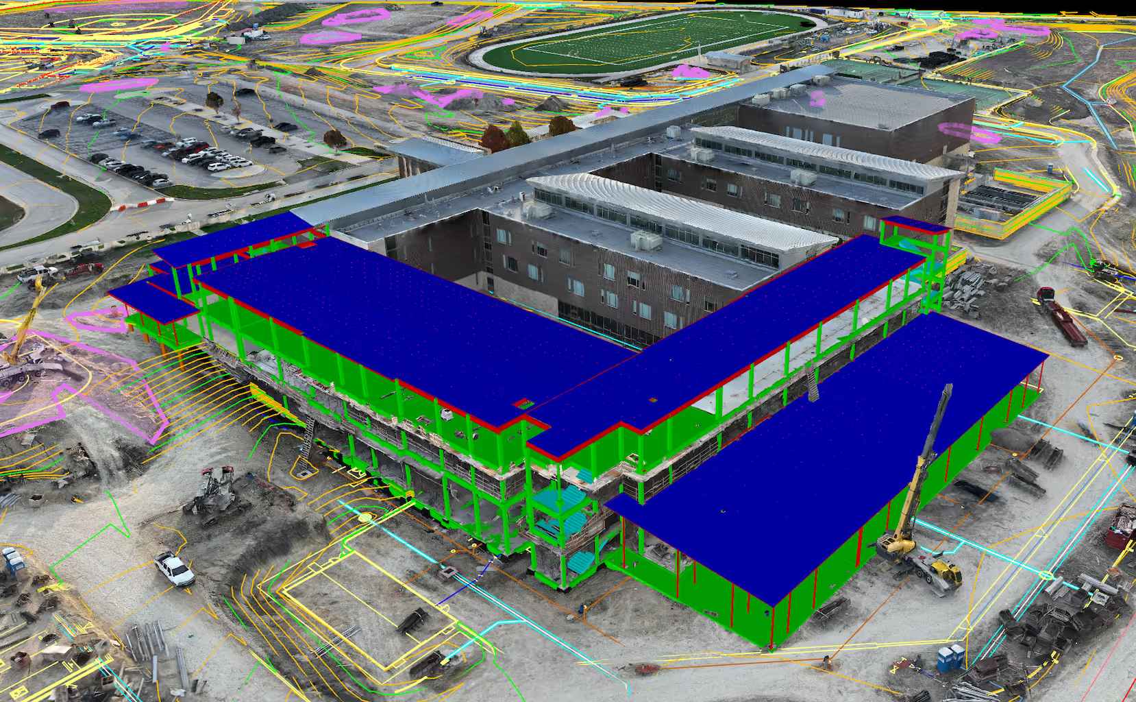
In its simplest form, drone photogrammetry is the art and science of taking precise measurements from aerial photographs. It involves capturing hundreds or even thousands of overlapping images of a site or structure from multiple angles and altitudes using a drone. Specialized software then analyzes these images, identifying common points to stitch them together, creating incredibly detailed 2D maps and 3D models.
Think of it like a super-powered jigsaw puzzle. Each photo is a puzzle piece, and the photogrammetry software figures out where those pieces fit to reveal the big picture. The result is a digital twin of your construction site – a highly accurate representation that allows you to:
- Track progress: Compare the real-world state of your project to design plans, quickly identifying discrepancies.
- Calculate earthwork volumes: Accurately measure stockpiles and excavations for inventory management and payment calculations.
- Inspect hard-to-reach areas: Safely get up-close views of roofs, facades, or infrastructure without the need for scaffolding or lifts.
- Improve site safety: Identify potential hazards and monitor changes over time to mitigate risks and keep your people safe.
How drone photogrammetry works
While the end result of drone photogrammetry might seem like magic, the process follows a structured workflow. Here's a more detailed look:
- Mission Planning: Before takeoff, flight planning software is used to create an automated flight plan. This plan ensures the drone captures images with the right overlap, oblique angles, flight altitude, and camera settings for the best possible data quality.
- Image Capture: The drone flies the predetermined route, snapping photos at regular intervals determined during the mission planning stage. Ground control points (GCPs) – physical markers with known coordinates – might be placed on the site for increased accuracy. These GCPs serve as reference points to calibrate the output data, rotating and translating it into the correct 3D coordinate system.

- Data Processing: The hundreds (or even thousands) of images, along with any GCP data, are uploaded to powerful photogrammetry software. This software analyzes the images, finding common points and identifying their position in 3D space using a process called Structure from Motion (SfM).
- 3D Model Generation: Through complex calculations, the software stitches the images together, generating a point cloud. This point cloud forms the basis of detailed 3D models which provide an incredibly realistic representation of site conditions.
- Orthomosaic Creation: Alongside 3D models, the software produces a high-resolution orthomosaic map. It's essentially a stitched-together top-down image of the area, perfectly corrected for scale and distortions.
- Analysis and Utilization: Outputs like 3D models, orthomosaics, and digital elevation models are brought into construction management software such as Procore or Autodesk Construction Cloud, CAD programs such as Civil3D or Revit, and GIS tools such as ESRI ArcGIS. This unlocks deliverables like cut/fill calculations, topographic surveys, as-built comparisons, pre-pour quality verification, facade inspections, overall progress monitoring, and much more.

Key points to remember:
Quality data in, quality data out: Proper flight planning, precise image capture, and the use of GCPs all greatly impact the accuracy of the final model.
Software is key: Photogrammetry software options vary in features and complexity. Choosing the right software impacts your processing speed, output types, and the precision you can achieve.
Top drones for construction photogrammetry
Choosing the right drone is crucial for effective photogrammetry on your construction site. Here's a breakdown of some popular options and the factors to consider:

Fixed-wing drones:
Pros:
- Superb coverage: Can map hundreds of acres in a single flight. Great for corridor mapping and long, linear projects.
- Long flight times: Stay airborne for extended periods, reducing the need for multiple flights. While most multi-rotor drones can stay airborne for as long as thirty minutes, fixed wings can fly for an hour on average.
- Flight efficiency: Fixed-wing drones are more aerodynamic than quadcopters and other alternatives, ensuring the longevity of your drone’s battery life.
Cons:
- Runway requirements: Need a larger, clear area for takeoff and landing.
- Operational complexity: Can be more complex to fly than multi-rotors.
- Limited maneuverability: Not ideal for tight spaces or focused inspections.
- Cost: Fixed-wing solutions can be more expensive with a cost ranging from $10,000 to $50,000 for more advanced setups.
Example: WingtraOne Gen II (known for its VTOL capabilities, simplifying takeoff and landing)
Recommendation: If you're mapping corridors or long, linear projects and you have the budget, fixed-wing drones can be an excellent choice. The open, linear nature of projects like highways, railways, or pipelines is perfectly suited to the flight patterns and extended range of fixed-wing drones. This allows you to minimize operational complexity and maximize the area covered per flight. Fixed-wing drones excel in open areas with minimal obstacles, making them especially valuable for corridor mapping.

Multi-rotor drones:
Pros:
- Ease of flight: Simpler to learn and operate, even for novice pilots.
- Maneuverability: Can hover and navigate into tight spaces or around obstacles.
- Vertical takeoff and landing (VTOL): Can operate from confined areas, no runway or large open space required.
- Cost: Generally more affordable than fixed-wing options.
Cons:
- Shorter flight times: Require battery changes or recharging more frequently.
- Limited coverage: Better for smaller areas or focused inspections.
- Wind susceptibility: Prone to drift in windy conditions, potentially impacting accuracy.
Examples:
- DJI Mavic 3 Enterprise with RTK (the new industry standard)
- DJI Phantom 4 RTK (older model, previous industry standard)
- Skydio X10
Recommendation: The industry workhorse and most versatile machine is the DJI Mavic 3 Enterprise, offering RTK positioning to maximize accuracy and a mechanical shutter to take the highest quality photos while rapidly capturing a site. Unless you are capturing a long corridor or very linear project a multi-rotor drone offers the most versatility and performance for your money.

Key Factors When Choosing:
- Project Fit: Choosing between fixed-wing, multi-rotor, or hybrid solutions depends heavily on your specific site size, terrain, and the type of data you need. Using the wrong drone can compromise your results or drastically increase your operational costs.
- Accuracy Requirements: If centimeter-level survey data is vital, RTK/PPK capabilities become non-negotiable. This significantly influences your drone choice and software requirements. To take advantage of high accuracy drone mapping, you’ll need to ensure that your drone comes equipped with a RTK GNSS receiver, which can be fitted on either fixed wing or multi-rotor drones.
- Workflow Integration: Seamless compatibility between your drone, photogrammetry software, and the rest of your construction management tools will make your life a lot easier. Mismatches can cause delays and errors, so be sure you’re putting together a cohesive set of tools that play nicely together.
(Important Note: Regulations and local airspace restrictions may influence your drone choice.)
At DroneDeploy, we’re obsessed with making drone data insanely simple, from capture to final deliverable. Use the chat button in the lower left to get in touch if you’d like to go deeper on this topic.
Expand Your Knowledge: The Drone Hardware Guide

Want to explore the full spectrum of drone technology transforming the construction industry? Delve into our free eBook, "The Drone and Robot Hardware Guide 2024." This comprehensive resource will help you:
- Discover the latest fixed-wing and multi-rotor drones designed for mapping, inspections, and more.
- Understand the benefits and applications of different drone technologies.
- Make informed decisions about the best hardware solutions for your specific needs.
Download your copy of the Drone Hardware Guide and stay ahead of the curve!
Drone photogrammetry: (so much) more than just maps

Traditional surveys and mapping are just the beginning of what drone photogrammetry offers the construction industry. This technology provides a wealth of actionable data that goes far beyond simple visualization. Here's how drone photogrammetry can empower your entire construction workflow:
Site Logistics Mapping: Drone photogrammetry empowers you to visualize your construction site in detail, streamlining site logistics. Optimize material placement, plan efficient access routes, improve coordination with stakeholders, and track progress over time. This data-driven approach to site logistics reduces delays, saves costs, and ensures a smoother, safer workflow throughout your construction project.
Pre-Pour Inspection of Sleeves: Drone photogrammetry offers valuable insights for concrete sleeve pours, streamlining your workflow and reducing costly errors. After the pour, your composite sleeve drawings can be overlaid to high-resolution aerial imagery to help you quickly verify the placement of sleeves and spacers, check formwork, and even locate rebar and post-tension cables. This assists VDC engineers with remote QC of penetrations and minimizes the need for expensive slab scanning.
For even greater efficiency and accuracy, DroneDeploy's Concrete AI Sleeve Reports use advanced analysis of your drone data to automatically identify and locate sleeves, saving your team valuable time.

Facade Inspections: Get a close-up look at rooftops, infrastructure, and hard-to-reach areas without the need for expensive scaffolding or dangerous climbs. High-resolution 3D models can even be used to identify subtle defects or early signs of wear and tear.
Learn more about facade inspections here.
Thermal Analysis: Thermal sensors mounted on drones can detect issues like heat leaks in building envelopes, malfunctioning equipment, or potential moisture problems. This data can guide preventive maintenance and save on energy costs.
BIM Integration: 3D models generated through photogrammetry can be seamlessly imported into Building Information Modeling (BIM) software. This allows for clash detection, as-built comparisons during construction, and more informed project management decisions.
Enhanced Communication and Collaboration: With shareable maps, 3D models, and annotated overlays, drone photogrammetry makes it easy to communicate progress or highlight issues with stakeholders, subcontractors, and clients regardless of their physical location.
The Potential is Limitless
As drone and software technology continue to evolve, the applications of photogrammetry in construction will only expand. Integrating drone data with artificial intelligence (AI) promises even greater efficiency gains and automated issue detection.

Streamlining your drone operations with DroneDeploy
Building and maintaining an in-house drone operation can be complex and time-consuming. That's where DroneDeploy and its Flight Services program come in.
DroneDeploy provides a comprehensive software platform that simplifies every stage of your drone workflow, from flight planning to advanced data analysis. When you need on-demand aerial data or your company is not set up to support in-house pilots, order a drone flight right in our platform, it’s as easy as ordering an Uber!
With a few clicks, you can:
- Order missions: Specify your site location and data requirements.
- Ensure rapid turnaround: Receive processed, accurate maps and models within days.
- Seamlessly integrate your data: Import your data directly into DroneDeploy for analysis, comparison, and collaboration.
By partnering with DroneDeploy, you gain the benefits of drone photogrammetry without the operational hassle. This allows you to focus on what you do best – building.
Ready to see how drone photogrammetry can transform your construction projects? Explore DroneDeploy's solutions and Flight Services today.

.png)
FAQ
Related articles


Ready to manage your data from the very start?
Book a quick call to see how DroneDeploy streamlines capture from construction through building ROI.