Seven Ways to Improve the Accuracy of Your Drone Maps
.svg)

Quick Summary
- The article walks through seven practical tips to boost map accuracy: fly in good weather, use a high-resolution camera, fly lower, increase image overlap, use a mechanical shutter, add ground control points (GCPs), and operate a drone with RTK GPS.
- It explains why each matters — for example, flying lower and increasing overlap gives your mapping software more “common points” between images, which helps stitching and improves accuracy.
- It also clarifies that if you’re doing serious “global accuracy” work (like overlays, design integration), things like GCPs or RTK matter a lot more than for simple inspections or marketing maps.
As we talked about in an earlier post, advances in technology mean it’s now possible to create highly accurate drone maps. Even straight out of the box, with average conditions and a typical drone, remote pilots can make maps with enough accuracy for a wide range of projects. For operators looking to improve the accuracy of their maps even further, there are a number of concrete steps that can take your maps to an advanced level suitable for commercial purposes across industries such as agriculture, construction, and mining.
With the right tactics and technology, it’s possible to create maps and 3D models that are accurate enough for even the most advanced projects. Whether you’re a specialist who wants to use drones to increase the efficiency of your existing day-to-day workflow, or a drone service provider looking to expand the range of your business, this post should help you improve the overall accuracy of your drone maps with some key best practices to keep in mind moving forward.
On that note, here are seven ways to improve the accuracy of your drone maps:
- Consider the weather
- Use a high-resolution camera
- Fly at a lower altitude
- Use a higher overlap
- Use a mechanical shutter camera
- Capture ground control points
- Operate a drone with RTK GPS system
Consider the Weather
It may sound basic, but it always bears mentioning that weather conditions greatly affect image quality, which in turn affects a map’s overall accuracy. Strive to fly while the sun is highest in the sky and avoid weather patterns such as high winds and cloud cover.
Agriculture expert Chad Colby, who has been using drones for several years, learned early on that the high winds and rolling cloud cover which are common on Midwestern farms should be avoided during mapping. Drones — especially lighter models — have difficulty staying steady during periods of high wind, which can make for poor image quality. Where agriculture is involved, the movement of crops in the wind blurs imagery even more. While it’s possible, flying in winds higher than 10 mph can have a negative impact on the overall quality of your drone maps. Learn more by watching our recent webinar.
“10 am-2 pm is going to give you the best light [for mapping].” -Chad Colby, Colby Agtech
Rolling cloud cover is also problematic, because consistent imagery throughout an entire map is important, and rolling clouds tend to create shadows and inconsistent light. To this end, drone operators should always try to plan missions in advance, know the weather and take steps to avoid mapping in poor conditions.
Use a High-Quality Camera and Sensor
One of the simplest things you can do to improve accuracy is to increase the resolution of your individual images, which can be achieved by using a high-quality camera with a powerful sensor, like the ones found on Inspire 2 and Phantom Pro 4. Using a better camera results in much more advanced imagery with a higher resolution. For operators looking to upgrade further, some drone models also allow users to switch out cameras and sensors.
What exactly does resolution have to do with map accuracy? Put simply, increasing the resolution of an image decreases its ground sampling distance (GSD), or in other words, it reduces the space between individual pixels in an image. Because drone mapping software like DroneDeploy processes maps by taking a series of individual images and matching the common points between them, the more common points that can be matched, the higher the accuracy of the map. An image with a more pixels contains more information, which means there is a greater probability of matching common points.
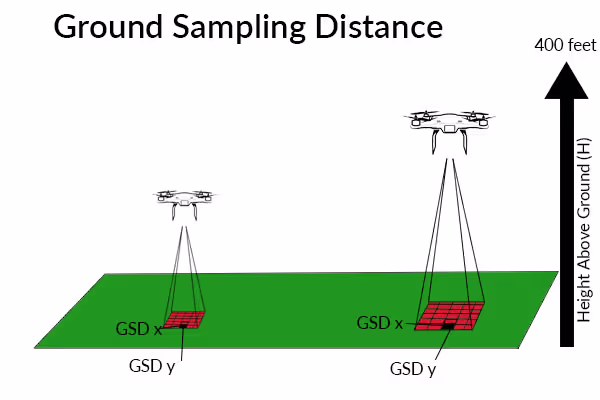
Fly at a Lower Altitude
Flying at a lower altitude serves two purposes. It captures more details in the landscape and therefore more data points to work with. Low altitude flights also result in a greater number of overall images, again increasing the probability of matching more common points on a map.
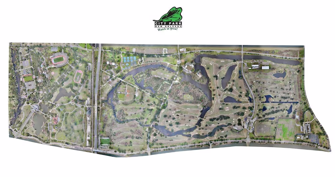
When he mapped New Orleans City Park for the second time, Ian Cotita of CAVU Media Group discovered the difference decreasing the altitude of a flight can make. For his second flight of the 1,300-acre park, Ian decreased his altitude by 25 feet. This, combined with increasing his overlap, resulted in an additional 2,500 images compared to his first flight. “We really pushed the envelope by going lower…but it was worth it,” says Ian.
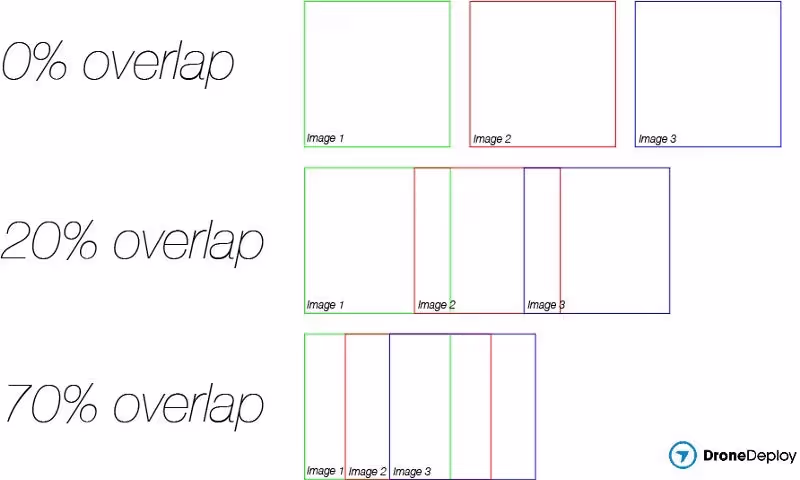
Increase Overlap
Increasing the overlap for a flight is another way to create more matched points and greater accuracy. Overlap refers to the percentage of both sidelap and frontlap. Sidelap is the percentage of overlap between each leg of a flight, while frontlap refers to the percentage of overlap between one image and the next. DroneDeploy’s default overlap is set at 60/70 in order to find a balance between accuracy and large image quantity. Many drone operators adjust the overlap depending on the needs of a particular project, striking a balance that creates the right amount of accuracy for the project’s outputs.
Use a Camera with a Mechanical Shutter
Many out-of-the-box drone cameras use a rolling shutter. This means that the camera records each frame line-by-line from top to bottom. When taking videos or photographs, this helps reduce motion blur. However, it can also sometimes cause what’s known as “rolling shutter effect,” where surfaces in a photograph appear warped because the camera-object relation changed before the full image was recorded. An image that is warped in this way makes it difficult for drone mapping software to match points on a map, which as we talked about above, negatively affects the map’s accuracy.
Upgrading to a camera with a mechanical shutter helps solve this problem, because in this case, the sensor records all of the lines of the frame nearly simultaneously, rather than line-by-line. Both the Phantom 4 Pro and the Inspire 2 are equipped with mechanical shutter cameras. Drone operators who have had problems with warped images due to rolling shutter effect may want to consider using one of these options.
Capture Ground Control Points
Some projects only need a high degree of relative accuracy, meaning a given point on the map is accurate relative to other points within the same map. For other projects — like geo-referenced overlays, design documents and land title surveys — it’s important to also have a high degree of confidence that the latitudinal, longitudinal and elevation measurements of a map are accurate. This is known as global accuracy.
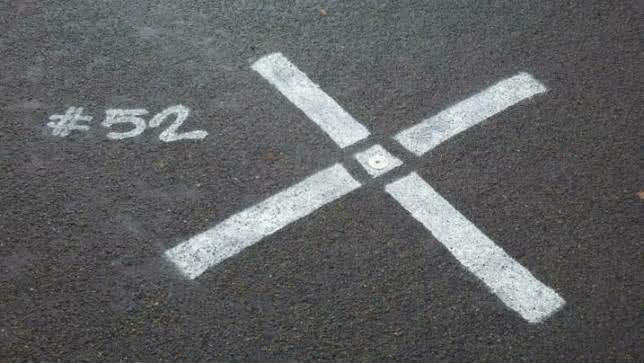
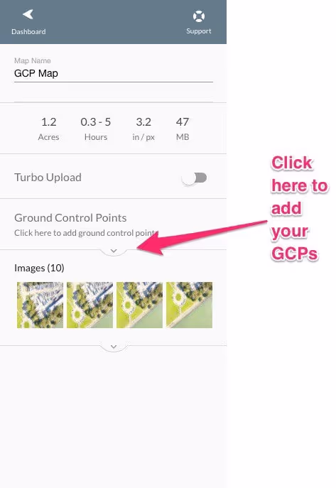
For projects that need this additional level of global accuracy, it is important to take additional steps to place the map within the fixed coordinate system of the real world. One way to do this is by using ground control points (GCPs.) Using GCPs essentially entails creating a series of ground markers in your area of interest prior to your flight and then manually recording the GPS coordinates for those markers. Enterprise and business users now have the ability to process ground control points directly in DroneDeploy. The existence of these GCPs allows DroneDeploy’s software to more accurately rectify your map within the known coordinate system.
When referring to the use of ground control points, which greatly improve a map’s global accuracy, Hunter Cole of construction company Brasfield & Gorrie puts the decision this way:
“If we’re going to make a critical determination off of the data set, absolutely we’re going to use GCPs. If it’s more for a marketing effort or we’re making smaller relative volumetric measurements, we may not bother with GCPs on that site.”- Hunter Cole, Brasfield & Gorrie
Operate a Drone with an RTK GPS System
To improve global accuracy, operators can use a drone that has an RTK GPS system, such as the senseFly eBee RTK drone. This system uses a portable base station to transmit accurate GPS data directly to the drone, allowing you to know the precise coordinates of where a drone image was captured.
DroneDeploy announced in February that our map engine is now able to generate maps from senseFly eBee RTK drone images. Civil Engineering firm Landpoint helped DroneDeploy test these new capabilities and found that the eBee RTK data processed with DroneDeploy’s updated image stitching algorithm had similar global accuracy (within 3 cm) as a second test map generated using GCPs.
Every drone mapping project is unique. Some require a high level of local accuracy, while others require a high level of global accuracy. Whatever the project, by utilizing best practices and quality technology, drone operators can improve the accuracy of their maps and create quality data that is suitable for even the most complex projects.
Where to Learn More
To learn more about what levels of accuracy are needed for different types of projects, make sure to read to read our earlier post, Accuracy in Drone Mapping: What You Need to Know. For more information about the techniques discussed in this post, be sure to consult our support documentation, including:
.png)
FAQ
Related articles


Ready to manage your data from the very start?
Book a quick call to see how DroneDeploy streamlines capture from construction through building ROI.