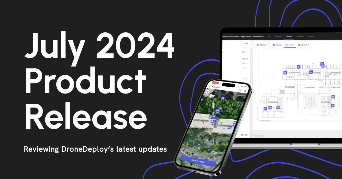
July 2024 Product Release Blog
.svg)

Quick Summary
DroneDeploy's July release includes major updates across Ground and Aerial. New Interior PDF Downloads make sharing interior views with clients easy. Fixed Camera support for SiteKick and improved overlay and map filters on mobile enhance visibility and project tracking. Ground robots like Spot now support location-based 360 walkthroughs.
On the Aerial side, Matrice 350 RTK and Anzu Raptor are now in beta, with improved GCP management, controlled map filters and badges, and annotation grouping for clearer project organization. Mavic 3E Live Map delivers instant on-site previews, while DJI Dock safety improvements offer enhanced visibility, weather checks and airspace alerts.
Exciting news from DroneDeploy! We’re rolling out new features and improvements in our July release to enhance your operations.
DroneDeploy Ground
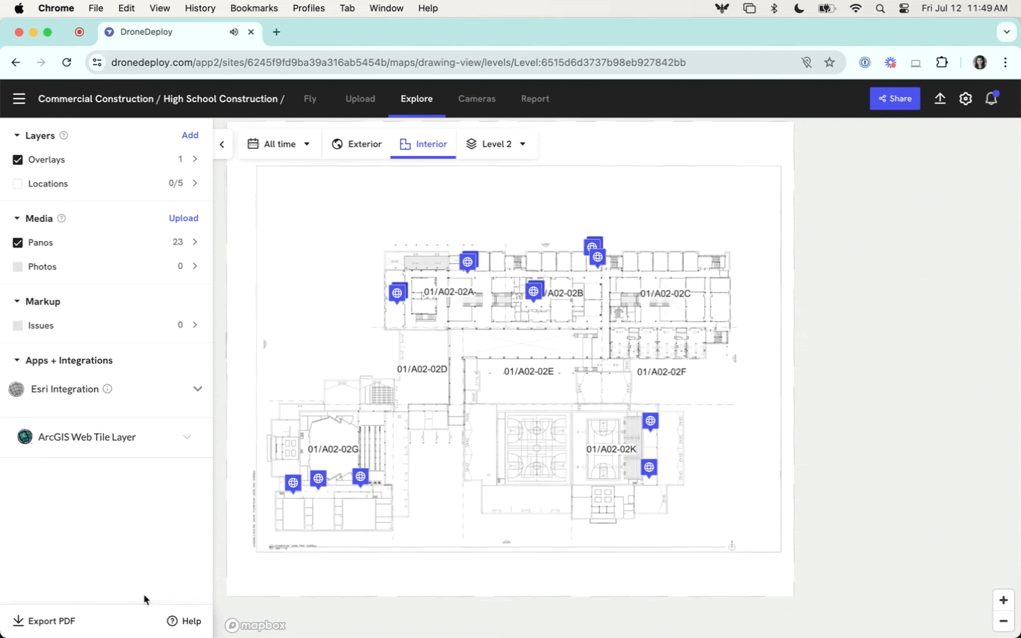
- Interior PDF Downloads - Instantly generate a PDF of the current interior view, including markers for all media, to deliver a filtered view of the project to key clients and stakeholders.
- Fixed Camera - SiteKick Support - Fixed camera data in the DroneDeploy platform centralizes all reality capture information, making it easier for project teams to remotely monitor sites for security purposes, tracking deliveries, and more, all while accessing their aerial and ground data.
- Overlay and Map View Filter on Mobile - Proactively select which overlay is displayed and captured, and change which orthomosaic map is seen on the exterior for additional context such as blueprints, shop drawings, or engineering documents at any level.
DroneDeploy Aerial
- New Supported Hardware Coming Soon: Matrice 350 RTK and Anzu Raptor - We’re excited to invite you to join our beta testing program if you own either of these drones.
- High Accuracy Improvements - Project Level GCPs, and High Accuracy Filters and Badges improve ease-of-use and efficiency.
- Annotation Groups - Combine annotations into groups that make sense for your project. No matter how you choose to organize your annotations, this new feature ensures your projects are more navigable and organized.
- Live Map for Mavic 3 Enterprise - Live Map preview is available immediately after flight and reduces the need to drive to the office to upload data so critical decisions can be made while in the field.
- DJI Docked Drone Safety Improvements - Fly safer and save time with docked drone improvements including cameras on the dock, weather conditions and DJI Airsense Alerts.
For a list of all July releases, check out the release notes.
DroneDeploy Ground
Interior PDF Downloads make it easy to share with your clients
Having a sharable report with all captured media pins and walks for a level on a drawing is an indispensable way to review daily or weekly progress or check the status of an issue.
We are happy to announce that the new interior PDF Download allows users to instantly generate a PDF of their current interior view, including markers for all media (incl. any selected Walks).
Now you can deliver a filtered view of your project to key clients & stakeholders, without them needing a DroneDeploy login.
New Fixed Camera Partner, SiteKick Announced!
In our April launch, we released our Fixed Camera functionality as an Open BETA for our Enterprise customers. While we are still iterating on the final capabilities from customer feedback, we are excited to announce the addition of SiteKick to the list of supported Fixed Camera partners:
Camera views from other camera providers are also supported, so please try pasting them into the app, or ask your CSM for assistance if it’s not yet supported and you’d like us to add them to our allow list. Go to our Support Article to learn more.
New Overlay and Map View Filters in DroneDeploy Ground Mobile
Previously, the default view in the DroneDeploy Ground mobile app was limited to the first overlay uploaded. While functional, this default view restricted users to a predefined context, potentially missing out on important details useful for adjustments before capture.
With the latest update, users can now proactively select which overlay to display and capture against. This enhancement provides additional context, allowing users to leverage overlays displaying blueprints, shop drawings, or engineering documents at any level.
Additionally, DroneDeploy Ground Mobile app users can now choose which orthomosaic map to display on the exterior, breaking free from the limitation of the most recent Ortho map.
DroneDeploy Ground Robotic 360 Walkthrough now uses Locations
We are excited to announce that you can now use your preset DroneDeploy locations to send your Boston Dynamics Spot or other supported ground based robot to capture autonomous 360 walkthroughs! This new feature allows DroneDeploy users, who have already created locations within their project for aerial and/or ground-based applications, to sync these locations with Spot for robotic captures.
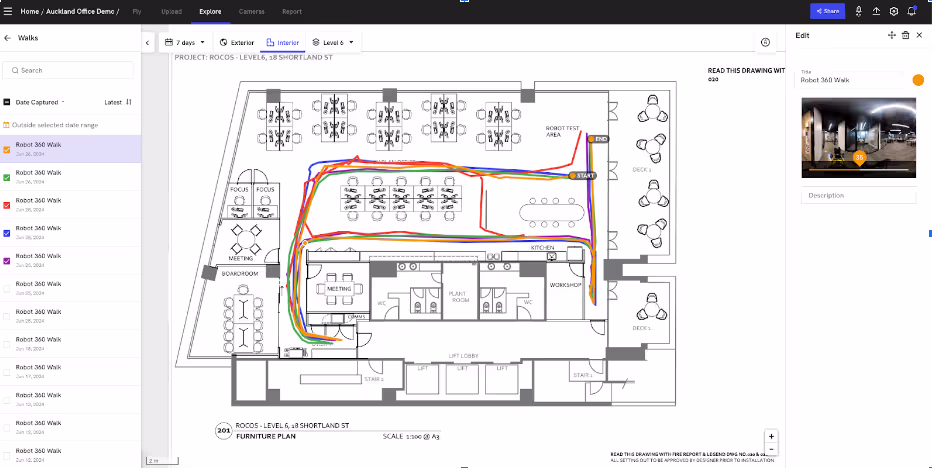
After your ground based robot completes a walkthrough aligned to a specific location, the walkthrough will appear in the DroneDeploy Interior view as a layer on-top of a plan sheet. Users can then leverage a location to quickly view their robotic walks with specific site context along-side their manual walks collected with a 360 camera.
DroneDeploy Aerial
New Supported Hardware Coming Soon: Matrice 350 RTK and Anzu Raptor
The DroneDeploy Flight app is now in open beta testing to support all mission types for:
- Matrice 350 RTK + Zenmuse P1 camera
- Anzu Raptor
We’re excited to invite you to join our beta testing program if you own either of these drones.
Comprehensive documentation is available for both the Matrice 350 RTK + Zenmuse P1 camera and the Anzu Raptor. If you’re interested in contributing to our testing efforts, please contact our support team. We look forward to your participation!
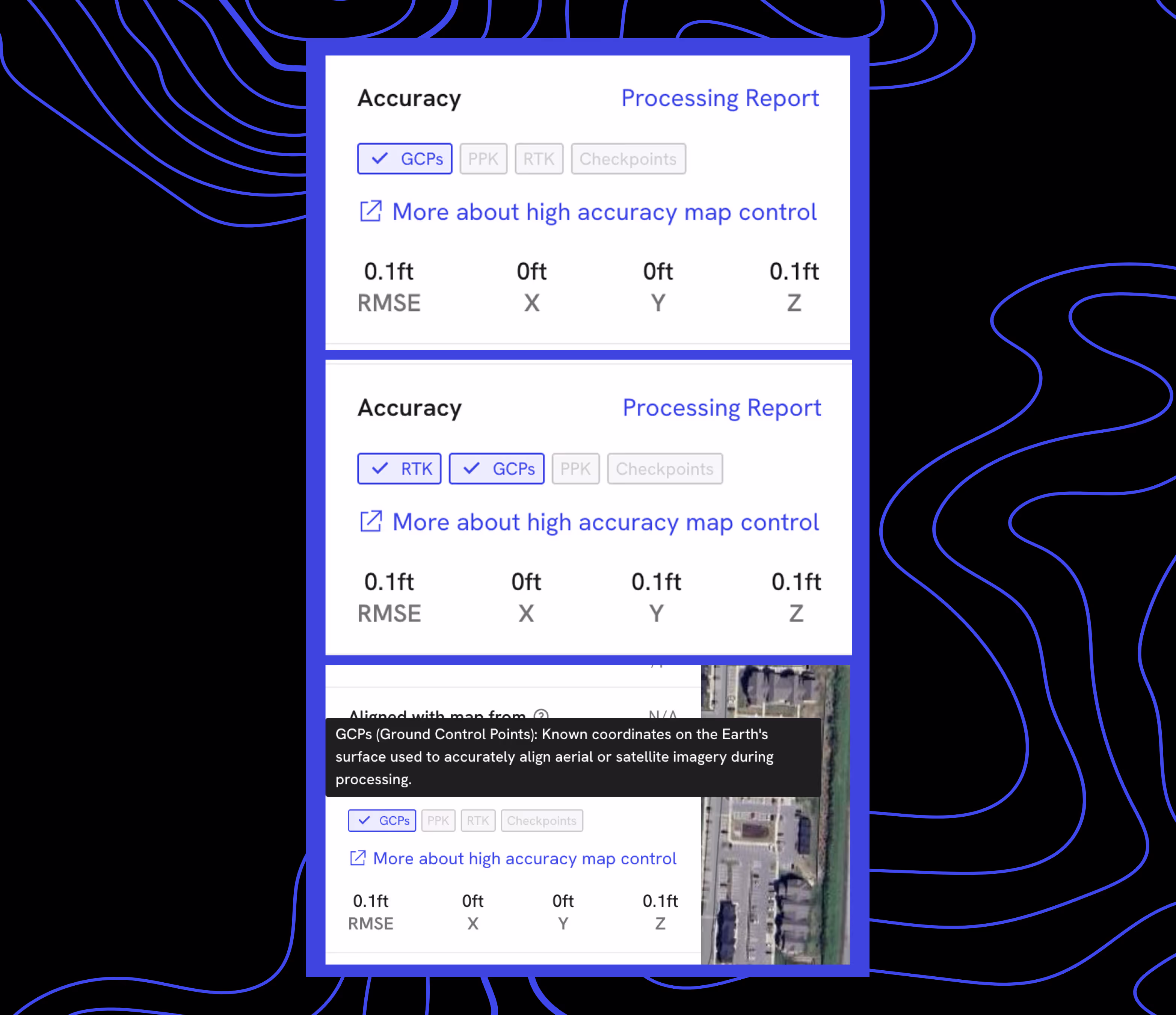
High Accuracy Improvements
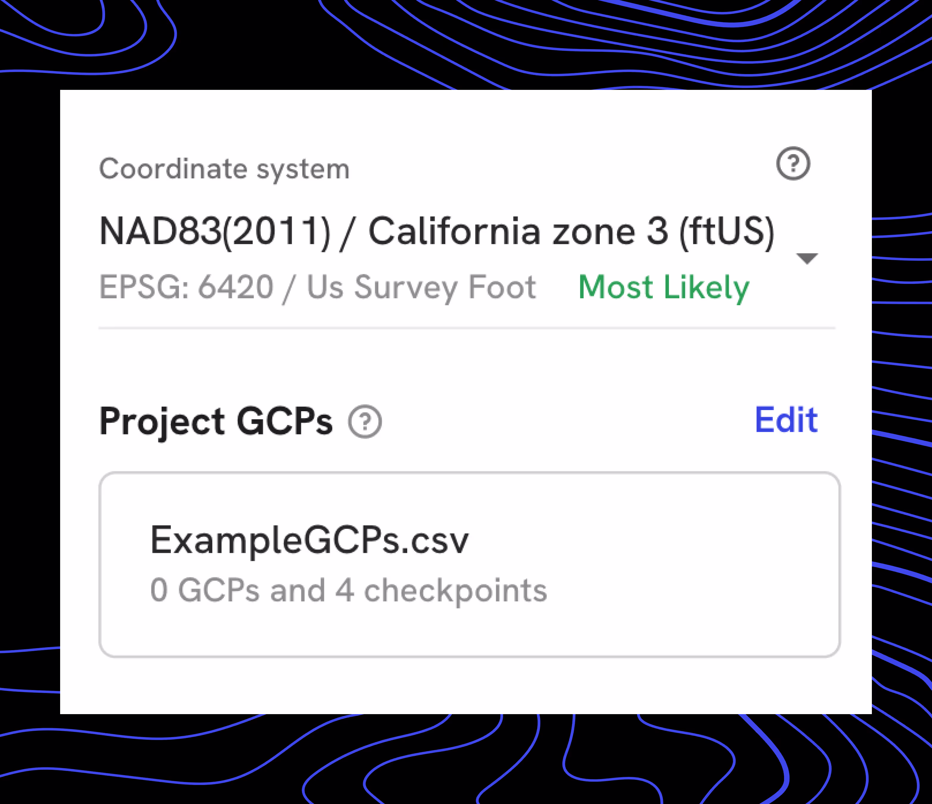
Project Level GCPs - Ground Control Points (GCPs) can now be saved directly to the project after upload, making them available to select for any new maps, without re-uploading each time. You can overwrite your saved GCPs at any time if needed.
Here's why you'll love it:
- Effortless Setup: Once you set your GCPs, you can forget about them. They’re saved to your project, ready for any new maps you create.
- Time-Saving: No more uploading .csv files again and again or trying to tell another pilot which GCP to upload for the next flight. Save time and reduce confusion among stakeholders with a streamlined, consistent approach.
Controlled Maps - Filter - See and filter which maps leverage High Accuracy settings and features from DroneDeploy to make measurements or compare over time. A new “Controlled” filter is applied to maps flown with additional controls, such as GCPs/Checkpoints, PPK, and RTK. Now you can easily locate flights that used high accuracy settings among other flights that did not.

Controlled Maps - Badges - Easily understand if a given map was flown with GCPs, RTK, PPK, or Checkpoints without diving into the processing report. Hover over the control-method badge to receive an explanation describing the respective technology.
Annotation Groups to Organize your Project
Keeping track of all your annotations can be a real challenge, especially when you're juggling multiple analyses or collaborating with a large team. That's why we're thrilled to introduce our latest feature: Annotation Groups!
Now, you can combine annotations into groups that make sense for your project. No matter how you choose to organize your annotations, this new feature ensures your projects are more navigable and organized.
Imagine you're running an analysis for solar panels and another for stockpiles. Instead of dealing with a messy list of 100 solar panels and 20 stockpiles, you can now group them into neat folders. This makes finding and managing your annotations easier.
This enhancement doesn't just improve organization—it also ensures quality measurements and streamlined analysis.
Live Map for Mavic 3 Enterprise
Say goodbye to driving back to the office and waiting for data to upload and process. With M3E Live Map, you get an immediate, low resolution map of your field or job site that is available offline.
For construction projects, this means you can create quick overlays for flight planning based on the most up-to-date site conditions, even if satellite imagery isn't current.
In agriculture, M3E Live Map allows you to make immediate post-flight assessments, providing crucial plant health details to landowners for prompt investigation and mitigation.
With M3E Live Map, you get the insights you need, right when you need them, making your workflow more efficient.
Safety Improvements to DJI Dock Integration
We’re excited to announce some updates to our DJI Dock integration that make your drone operations smoother and safer than ever!
- Camera Toggle During Flight: Now you can switch between the dock and drone camera during flight to ensure the dock is clear of any obstructions, like birds, when the drone is returning.
- Wind Speed Estimation: Get accurate wind speed estimates from the drone as it takes off, since the dock is usually sheltered and wind readings might be lower there.
- DJI Airsense Alerts: Stay safe with alerts for nearby aircraft equipped with ADSB-IN.
We’ve also added some useful features to the Dock Automation Pre-flight Checklist:
- Weather Check: Get real-time weather information from the dock to confirm conditions are favorable for flight.
- Dock Camera Check: Ensure the dock is fully functional and clear of people before takeoff.
- Drone Condition Verification: Open the dock to verify the drone’s condition before it takes off.
.png)
FAQ
Related articles


Ready to manage your data from the very start?
Book a quick call to see how DroneDeploy streamlines capture from construction through building ROI.