The Nature Conservancy: Fueling Innovation & Tackling Environmental Challenges with Drone Technology

Quick Summary
The Nature Conservancy is using DroneDeploy to transform how it monitors and restores ecosystems—from mapping coral reefs in the Caribbean to tracking mangrove health and surveying prairie dog habitats in Montana. DroneDeploy’s high-resolution imagery and 3D models help the organization answer local-scale conservation questions faster and more accurately, while reducing time in the field and their carbon footprint. These tools enable coral bleaching detection, mangrove biomass tracking, and prairie dog colony monitoring, helping scientists and land stewards make better decisions with fewer resources. As drone use expands, The Nature Conservancy continues scaling its efforts to meet urgent environmental challenges.
Mapping coral reefs, rehabilitating mangrove populations, and restoring rangeland for conservation are no easy feats. In fact, scientists and practitioners from The Nature Conservancy spend countless hours in the field using diverse methods to complete these tasks in order to tackle a host of environmental challenges like deforestation and coral bleaching. But with so many competing priorities, the non-profit needed a way to capture sharper images and more accurate data to address local scale questions, all while decreasing the time and effort it took to do so. Because of its minimally invasive nature and easy data interconnectivity, drone software is the technology of choice for today’s conservationists. Below are three ways The Nature Conservancy uses DroneDeploy’s in-kind donation to support conservation and land management.
We’re at the forefront of discovery with drone and remote sensing technology. As humans, as land managers, and as wildlife biologists, we have this new perspective of how we can look at the world. We are able to look at data we never had before and answer brand new questions about the world around us.”

Jason Hanlon, Northern Great Plains Land Steward, The Nature Conservancy
Mapping Coral Reefs with Drone Data
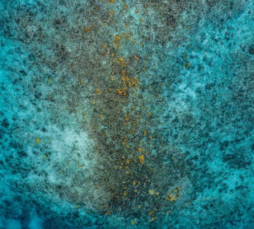
Drone data has been an essential part of The Nature Conservancy’s field survey program since 2014, opening up an entirely new niche of ‘personal remote sensing’ and local scale data collection. In particular, coral reefs face an overwhelming number of threats, including warming oceans, marine pollution, and overfishing. Reef managers must figure out how to better protect and restore these habitats in order to maintain the numerous ecosystem services they provide to people.
Dr. Steve Schill, Lead Scientist of The Nature Conservancy’s Caribbean Division, sees drone technology as a key conservation tool to help answer these questions. The clear waters of the Caribbean provide an ideal environment to map and monitor changes in coral reef communities. As Dr. Schill puts it, “Our job is to pinpoint where these reefs are, map what their condition is, and understand how they’re changing.”
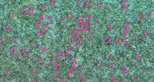
In tandem, The Nature Conservancy has designed and built one of the Caribbean’s largest on-land facilities to grow coral and experiment with different genotypes to see how these corals respond to the impacts of climate change. The maps created by DroneDeploy have been incredibly useful for monitoring the survival and changing status of coral outplants.
“Drones are providing coral monitoring at an entirely new scale, including accurate depth modeling, species mapping, bleach detection, and tracking change across space,” Schill explains. “When coupled with dive surveys, these drone products become very powerful management tools to evaluate coral growth and loss, detect stress and disease, assess post-storm damage, and more effectively monitor restoration activities.”
Steve added that these drone products are so accurate that his team is now using them with machine learning technology to identify coral species by their spectral and contextual properties. This is a one-of-a-kind project that has never been done at this scale, making the results all the more important.
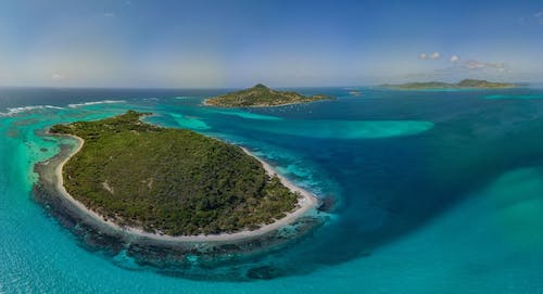
Monitoring Mangrove Populations with Drone Tech
Mangroves are an essential part of the Caribbean’s landscape, helping with coastal erosion, carbon storage, fisheries production, storm protection, and other ecosystem services. Because of mangroves’ multitude of human benefits, it’s necessary to collect the health and structure of mangrove forests to ensure sustained growth.
Using multispectral sensors, Dr. George Raber, a Biological, Environmental, and Earth Sciences Professor from the University of Southern Mississippi, works with the Nature Conservancy to collect field data to feed into classification algorithms. From here, he uses DroneDeploy to create 3D visualizations for easy vegetation identification. Ultimately, this allows the team to compare changes in NDVI and biomass over time and determine the best measures to protect and restore these critical coastal habitats.
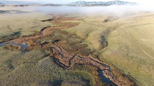
Building & Surveying Prairie Dog Towns
In what The Nature Conservancy refers to as “large-scale community-based conservation,” The Nature Conservancy leases tens of thousands of grassland acres to individual ranchers to promote healthy, sustainable habitats for wildlife on the Matador Ranch in Montana. Nicknamed “nature’s engineers,” prairie dogs are responsible for building self-sustaining ecosystems for owls, foxes, and more. Jason Hanlon, Northern Great Plains Land Steward, tells us that The Nature Conservancy offers financial incentives to ranchers for maintaining prairie dog habitats. Over 88 “prairie dog towns” are flourishing on the ranch, preserving crucial habitat lands.

To monitor the size of these communities, the team uses DroneDeploy to survey these areas – capturing hundreds of images per town. “Using drones has completely changed how we operate,” says Hanlon. In this minimally invasive manner, conservationists can use these maps with GIS coordinates to pinpoint changes over time and reduce grazing costs for the ecosystem services that this critical habitat generates.
Since utilizing drone software, The Nature Conservancy has significantly increased the number of flights and images taken per project. By increasing the accuracy of their data collection and decreasing the time it takes in the field to capture information, utilizing drones has also reduced their carbon footprint - something critical to The Nature Conservancy’s mission. In 2021, the organization doubled its number of flights and images taken, and it is on track to do so again next year.
We’re looking forward to continuing to support The Nature Conservancy as they tackle the world’s most pressing environmental challenges through our philanthropic arm, DroneDeploy.org. If you’re interested in drone use in conservation, watch our webinar on growing your drone program, or apply to our DroneDeploy.org program.
FAQ
Related articles
Ready to manage your data from the very start?
Book a quick call to see how DroneDeploy streamlines capture from construction through building ROI.
.svg)
.png)
