How autonomous construction scanning creates a repeatable site record
.svg)
Quick Summary
Autonomous robots equipped with laser scanners and 360 cameras can walk predefined routes across active construction sites, capturing consistent visual and spatial data on a repeatable schedule. Teams use this data to compare as-built conditions against BIM models, track progress over time and maintain a reliable site record without pulling crew members off productive work. This piece covers how the technology works, what it looks like in practice and where DroneDeploy Robotics fits into the workflow.
On an active site, conditions change daily. Concrete gets poured, steel goes up, trades rotate through. The teams managing that work need a current record of what's actually installed, and they need it compared against design intent. Getting that record consistently across a large project takes real effort. Walking every floor with a scanner or camera, on a set schedule, from the same vantage points, is repetitive work that pulls experienced people away from higher-value tasks. When it doesn't happen on schedule, the record has gaps. DroneDeploy's robotics platform addresses this by letting autonomous robots handle the capture on a repeatable route, so the documentation stays current without adding headcount.
Key Takeaways
- Automated Progress Tracking: Autonomous robots solve the difficulty of consistent, daily construction site scanning.
- Advanced LiDAR Integration: Modern scanners capture up to 2 million points per second and can be mounted on mobile robots for real-time digital twins.
- Increased Accuracy: Robots follow predefined routes, eliminating human error and providing repeatable data for BIM comparisons.
- Cost & Safety Benefits: Automation reduces labor costs, allows for night-time surveying, and keeps workers out of hazardous environments.
Ground robots and quadrupeds equipped with laser scanners and 360 cameras now operate on active construction sites across the world. They follow predefined paths, capture spatial and visual data and return to their docking stations without human intervention. The capture happens on schedule. The data feeds directly into platforms where teams compare it against BIM models and prior captures.
How laser scanning and robotics work together
Laser scanners have been on construction sites since the 1990s. Early models were heavy, slow and required manual repositioning at every scan station. The Cyrax 2500, for example, weighed 29kg and captured 1,000 points per second. Current scanners capture upwards of 2 million points per second and weigh a fraction of that.
That reduction in size and weight is what made robot-mounted scanning practical. A scanner that once needed a dedicated operator and a tripod now rides on a quadruped that navigates stairs, uneven surfaces and active work zones.
The other shift is in registration and processing. Scans captured by a robot on a predefined route can be automatically registered and aligned, then compared against BIM models or previous captures. Combined with cloud-based processing and AI-driven analysis, the raw point cloud data turns into a structured record that teams reference from the office or the field.
What robots bring to construction site scanning
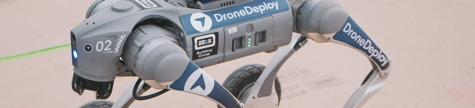
A quadrupedal robot like Boston Dynamics' Spot navigates stairs, ramps, uneven slabs and active work zones. Equipped with a laser scanner and 360 camera, it captures spatial and visual data as it moves through the site on a defined route. The robot doesn't need a dedicated operator walking alongside it. It follows waypoints, captures at each station and moves on.
The data flows into a platform where it is processed, registered and organized by date and location. Teams compare the captured conditions against BIM models, design drawings and prior captures. On DroneDeploy, aerial and ground data live in the same system, so a project manager can reference a drone flight from Tuesday alongside a robot walkthrough from Thursday without switching tools.
The practical advantage is consistency. A robot follows the same route, scans from the same angles and captures at the same level of detail every time. That repeatability makes it possible to track installed work against design intent with a level of accuracy that manual walkthroughs struggle to match across weeks and months of a project. When a superintendent needs to verify what was in place before drywall went up, the record is there.
How autonomous robot missions run on site
With DroneDeploy Robotics, teams define a route of waypoints across the site, set a schedule and let the robot execute. The robot wakes up, follows the route, captures at each station and returns to its dock. Missions run on a set cadence, whether that is daily, weekly or tied to specific project milestones. Capture happens during off-hours, between shifts or whenever the site is clear.
That scheduling removes the dependency on someone remembering to walk the site with a camera before a pour or a close-up. The mission runs. The data uploads. The record stays current. For teams managing multiple floors or buildings on the same project, the robot covers ground that would otherwise require dedicated staff rotating through each area on a fixed schedule.
Robots do occasionally encounter obstacles on active sites. When that happens, the platform alerts an operator who can intervene remotely through teleoperation controls. Low-latency video streaming gives the operator enough context to guide the robot past the obstruction and resume the mission. The workflow accounts for the reality that construction sites are messy, crowded and constantly changing.
Where construction robotics is heading
Robotic scanning works best as a layer inside a broader capture strategy. Drones cover the site from above. 360 cameras document interiors during walkthroughs. Robots fill the gap by providing consistent, repeatable ground-level capture on a fixed schedule without requiring someone to carry the hardware.
The benefits of a single robot performing site surveying are clear:
- Data Accuracy: Real-time, high-definition 3D data capture.
- Cost Efficiency: Significant reduction in manual labor costs.
- Worker Safety: Improved safety by keeping humans out of dangerous zones.
- Project Management: Early identification of delays or structural discrepancies.
On DroneDeploy, all three data sources live in one system. A project team can pull up an aerial orthomosaic from last week, compare it against a robot-captured point cloud from yesterday and overlay both against the BIM model. The AI layer analyzes what has been installed, flags deviations from design and generates structured progress reports by trade and location.
Teams adopting robotic capture typically start with a defined scanning schedule tied to project milestones or trade handoffs. The robot's route maps to the areas that matter most for that phase of work, whether that is structural steel verification, MEP rough-in documentation or pre-drywall condition records. As the project progresses, the route evolves with it.
Next steps
Next steps
If your team is evaluating robotic capture for active construction sites, start with the areas where consistent documentation matters most. Pre-pour verification, MEP rough-in records and pre-close conditions are common starting points.
DroneDeploy Robotics supports autonomous ground robot missions alongside aerial and 360 capture in one platform. Book a demo to see how the workflow fits your current projects.
.png)
FAQ
Autonomous construction scanning uses robots or drones fitted with LiDAR or 3D laser scanners to collect site data without manual operation. The robot follows a pre-programmed route, captures a point cloud of the site and makes that record available for comparison against BIM models or design drawings. Scans can be scheduled to run on a regular basis, including during off-hours, across any phase of a project.
LiDAR (Light Detection and Ranging) is the core technology. It fires laser pulses and measures return times to build a 3D point cloud of a surface or space. ALS, or Airborne Laser Scanning, is one specific application of LiDAR where the scanner is mounted on an aircraft to capture large areas of terrain from above. In construction, ground-based LiDAR mounted on robots or tripods is used more often for interior documentation, as-built verification and BIM comparison.
Laser scanning costs vary based on project size, site complexity, scan frequency and whether a human operator or an autonomous robot is performing the work. A single professional scan session carried out by a technician with a tripod-mounted scanner typically ranges from a few hundred to several thousand dollars, depending on the number of scan positions and the size of the space. Robotic autonomous scanning lowers the per-scan cost of repeat missions because it removes technician labor from each run.
The cost of a 3D scan-to-BIM workflow depends on building size, required scan density and how the point cloud is processed and modeled. For smaller buildings, basic scan-to-BIM work typically starts in the low thousands of dollars. Large commercial projects with high scan coverage and detailed BIM deliverables can run significantly higher. Scheduling autonomous robotic scans at regular intervals keeps the BIM current throughout construction without the labor cost of sending a surveyor each time.
Related articles


Ready to manage your data from the very start?
Book a quick call to see how DroneDeploy streamlines capture from construction through building ROI.