Mapping Aquatic Habitats with Drones
.svg)

Quick Summary
- The Nature Conservancy, which has protected 119M+ acres worldwide, is now using drones to gather critical environmental data — especially for fast-changing aquatic habitats where traditional surveys fall short.
- In Tomales Bay, CA, the Conservancy partnered with Hog Island Oyster Company and UC Santa Cruz to map eelgrass and study how oyster farming affects the surrounding ecosystem. Using DroneDeploy lets their scientists collect high-quality imagery even in remote areas with zero connectivity, thanks to offline mapping.
- CTO Matthew Merrifield says drones provide “primary science data” that captures fleeting environmental changes — making UAVs an essential tool for advancing conservation work today and in the future.
Conserving the lands and waters on which all life depends is no small task. But The Nature Conservancy is up to the challenge, working every day to protect our planet.
The Nature Conservancy is the leading conservation organization working around the world to protect ecologically important lands and waters for nature and people. Since starting in 1951, the organization — and their team of more than 600 scientists — has been wildly successful in achieving its goals. To date, they have protected more than 119 million acres of land and thousands of miles of rivers worldwide. With ongoing projects in 72 countries, the organization addresses threats to conservation involving climate change, access to clean water, ocean health, and everything in between.
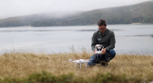
The Nature Conservancy Pilot Kirk Klausmeyer prepares his drone for take-off in Tomales Bay.
The team at The Nature Conservancy began using drones to help scientists in the field collect critical data to better understand what’s happening in aquatic habitats. Most recently they put DroneDeploy to work on a local project here in California with Hog Island Oyster Company and the University of California Santa Cruz.
We got the opportunity to speak with Matthew Merrifield, the Chief Technology Officer at The Nature Conservancy, about partnering with Hog Island Oyster Company and how his team used DroneDeploy to map aquatic habitats and assess the impact of oyster aquaculture on eelgrass in Tomales Bay.
We've found that drones can provide a lot of primary science data. The value-add of drones, is the ability to capture really ephemeral activities, things that change on the landscape really quickly.
Matthew Merrifield, CTO, The Nature Conservancy
Matt is leading the charge to integrate drone technology into field operations and sees drones playing a big role in achieving the organizations goals now and in the future.
In one project, they work with the Hog Island Oyster Company using DroneDeploy to map aquatic habitats as they assess the impact of oyster aquaculture on eelgrass in Tomales Bay, California. They must often fly in places where there's zero connectivity, so offline map support is essential.
"DroneDeploy seemed like the obvious solution for us." says Matthew Merrifield. "With the ease of use, you can get up and running right away."
.png)
FAQ
Related articles


Ready to manage your data from the very start?
Book a quick call to see how DroneDeploy streamlines capture from construction through building ROI.