GCPs: Everything you need to know
.svg)
Quick Summary
Ground control points (GCPs) are surveyed markers placed on the ground before a flight. Drone mapping software uses their known coordinates to anchor the map to precise real-world positions. Not every project needs them, but for surveying, earthwork quantities and design overlays, they're what separates usable data from data you can't defend.
Ground control points are one of those things that sound technical until someone explains them plainly. Once you understand what they do, you'll know immediately whether your project needs them – and how to set them up correctly.
In this blog we’ll cover what GCPs are, when to use them, how to place them and how DroneDeploy processes them. Let’s dive in.
What are GCPs?
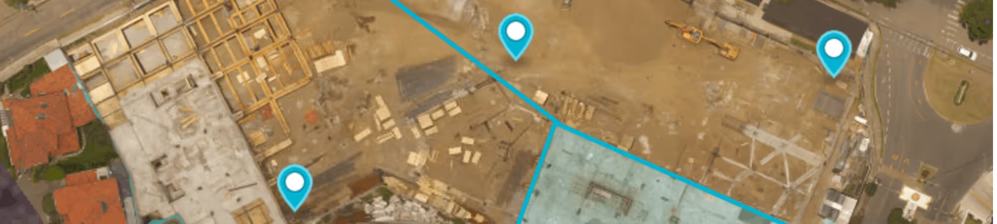
A ground control point is a high-contrast target placed flat on the ground with a precisely measured GPS coordinate at its center. During processing, the software uses those known locations – think of them as thumbtacks pinned to specific points on the map – to accurately position every other point in the dataset.
Without GCPs, your map relies on the drone's onboard GPS, which typically drifts by several feet. That's acceptable for general site awareness. It's not acceptable when quantities, design overlays or legal documentation are on the line.

When to use GCPs
Not every flight requires them. The decision depends on what you're doing with the data.
GCPs are worth the setup time when:
- Your deliverables are going to engineers, owners or regulatory bodies who expect documented accuracy
- You're calculating cut/fill volumes or stockpile quantities where elevation precision drives payment
- You're comparing drone data against CAD or BIM files and need the two to align precisely
- Your site is large enough that GPS drift compounds meaningfully across the dataset
For general progress photos, visual site checks or internal documentation, GCPs usually aren't necessary. For anything contractual or survey-grade, they are.

How to create GCPs and checkpoints
There's no single right way to make a GCP target. What matters is that it's clearly visible in aerial imagery — high contrast, large enough to identify from your flight altitude and sitting flat on stable ground that won't shift between your survey and your flight.
Many teams buy prefabricated panels. Others paint targets directly on pavement or fabricate their own from materials on site. Both work. A general rule: fly at 300 feet AGL with 70/75 frontlap and sidelap when using GCPs, though that changes depending on your site and accuracy requirements.
Checkpoints are a separate but related step. They look identical to GCPs on the ground, but they're withheld from processing. Instead of helping build the map, they're used afterward to verify it — comparing their known measured locations against where the map places them. To add checkpoints in DroneDeploy, include the word "checkpoint" in the GCP label in your CSV file.
The balance between GCPs and checkpoints matters. More GCPs improve map accuracy. More checkpoints improve your ability to prove that accuracy. A common starting ratio is 2 GCPs for every 1 checkpoint. ASPRS recommends 20 checkpoints to achieve a 95% confidence interval on your results.
How many GCPs do you need
The answer most teams want is a number per acre. The more useful answer involves altitude.
Think of GCPs as thumbtacks and each image as a link in a chain. A GCP in an image nails that link to the correct position in space. The more images between two GCPs, the more opportunity there is for small stitching errors to accumulate. A practical rule of thumb: 1 GCP for every 60 images captured.
That said, distribution matters as much as count. GCPs clustered in one corner of the site leave the rest of the map unconstrained. Spread them around the perimeter, add a few in the interior and put tighter coverage in areas where precision matters most — building pads, utility corridors, earthwork zones.
%20(1).png)
Automated GCP detection with DroneDeploy
DroneDeploy's Ground Control AI automatically detects and tags GCP locations in your imagery without manual input. After processing, you'll receive details in your processing email showing how many markers were tagged automatically along with a full accuracy report.
The system was initially trained on more than 200,000 human-tagged GCPs and continues to improve with use. When you correct a target the system misidentifies, you're helping refine the algorithm for future flights. Manual tagging is still available if you prefer it.
How to process GCPs
DroneDeploy needs specific information tied to each GCP to process correctly. The coordinate data, the target labels and the checkpoint designations all need to be in order before you upload. A full walkthrough is available in DroneDeploy's support documentation, including a video overview of adding GCP information to your maps.
A few things worth keeping in mind during processing:
- The more GCPs you include, the more accurate your map is likely to be
- The more checkpoints you include, the more confidently you can document that accuracy
- Checkpoint errors — not GCP errors — are the number to reference when someone asks how accurate the final deliverable is, since those points weren't used to build the map
Next steps
If you want to go deeper on building accuracy into your drone program, download our High Accuracy Guide. To see how GCP workflows run inside DroneDeploy, book a demo.
.png)
FAQ
Related articles


Ready to manage your data from the very start?
Book a quick call to see how DroneDeploy streamlines capture from construction through building ROI.