October 2025 Product Release
.svg)
Quick Summary
DroneDeploy’s October 2025 release boosts control and efficiency with lightweight drone support, geofencing, dock overrides, low-light 360 capture, BIM-to-pano comparison, and Autodesk sync – cutting rework and speeding site decisions.
The October Aerial release includes updates that are all about putting more control in your team’s hands. Whether you’re flying a lightweight drone in tight regulatory environments, defining geofences for safety, or taking manual control of docked drones for asset inspection – these updates are designed to keep your operations compliant, efficient, and responsive.
October’s Ground release keeps models current and aligned automatically, reducing rework and ensuring reviews reflect the latest design. It speeds quality checks and coordination with clear design-to-reality context and delivers sharper, reliable documentation even in low light with the newly released Insta360 X5.
DroneDeploy Aerial
→ DJI Mini 4 Pro Flight Support - Flight support for the DJI Mini 4 Pro, an affordable, sub-250g drone.
→ Geofences - Draw operational areas and exclusion zones directly in the web app to ensure compliance across teams and simplify audits.
→ Manual Flight for Dock - Instantly take over dock drone control mid-flight to inspect assets or other points of interest and resume automated missions seamlessly.
DroneDeploy Ground
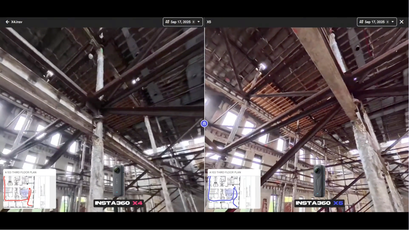
→ Insta360 X5 Support - 144% larger sensors and 8K resolution combine to brighten low light conditions and make every 360 walk a success.
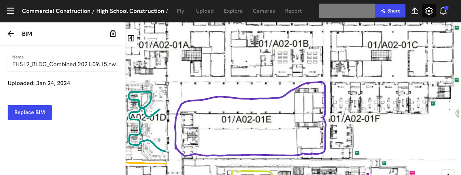
→ Upload New BIM Version Without Realignment- The new "Replace" button in project settings allows teams to update BIM models without losing existing alignments.
→ Auto Sync BIM with Autodesk Construction Cloud- Direct BIM import from Autodesk Construction Cloud eliminates file transfer steps ensuring models stay current automatically when new versions are uploaded to ACC.
→ BIM Compare versus Pano - Teams can now compare BIM models directly against 360-degree panoramic captures. This side-by-side comparison enables additional levels of quality control by showing design intent alongside actual construction progress in real-time.
For a list of all features launched as part of the October release, check out the release notes.
DroneDeploy Aerial
DJI Mini 4 Pro Flight Support
An ultra-light drone now available for automated flights in DroneDeploy. Ideal for regions with regulatory weight limits (sub-250g), the Mini 4 Pro gives new and growing teams an affordable way to scale.
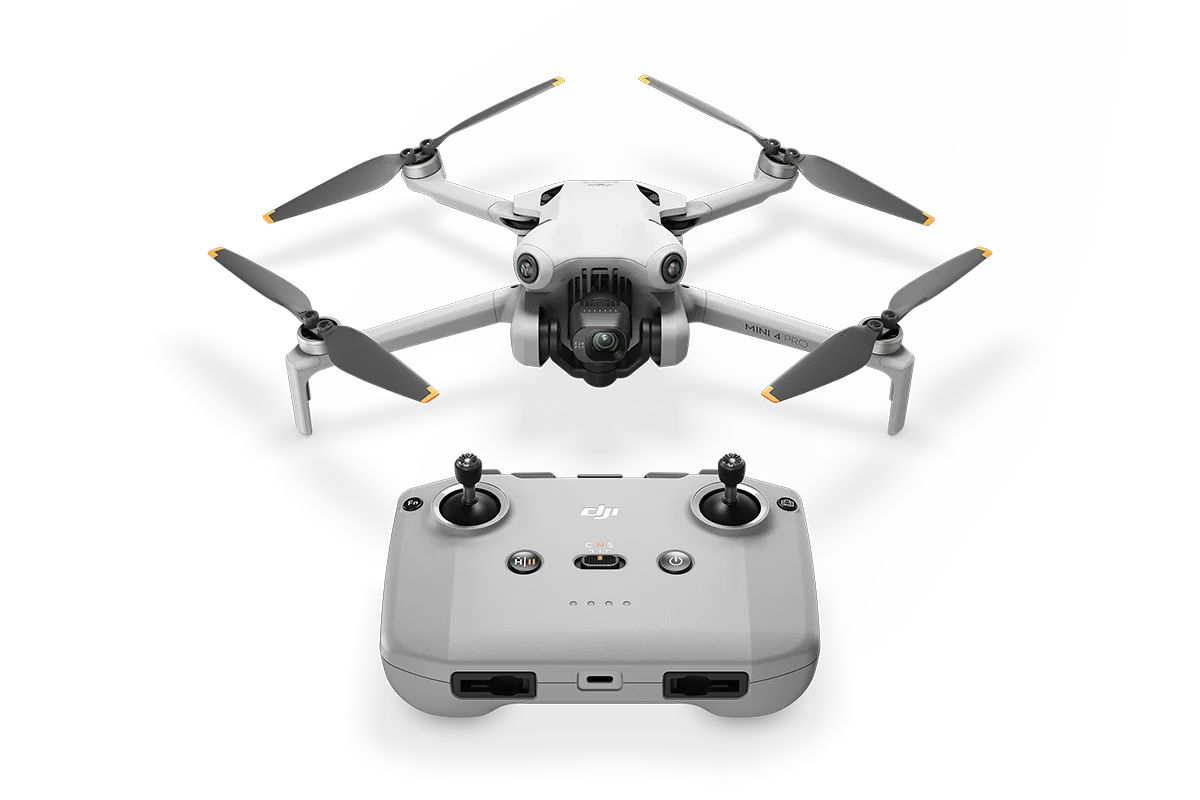
Feature Benefits:
→ Flies up to 45 minutes with the Intelligent Flight Battery Plus.
→ Weighs under 250g, making it ideal for EU and remote ID-exempt operations.
→ Capture maps, photos and video.
→ Priced from $759 USD, a great choice for budget-conscious programs.
Geofences
Define where drones can and can’t fly in minutes for safety and compliance.
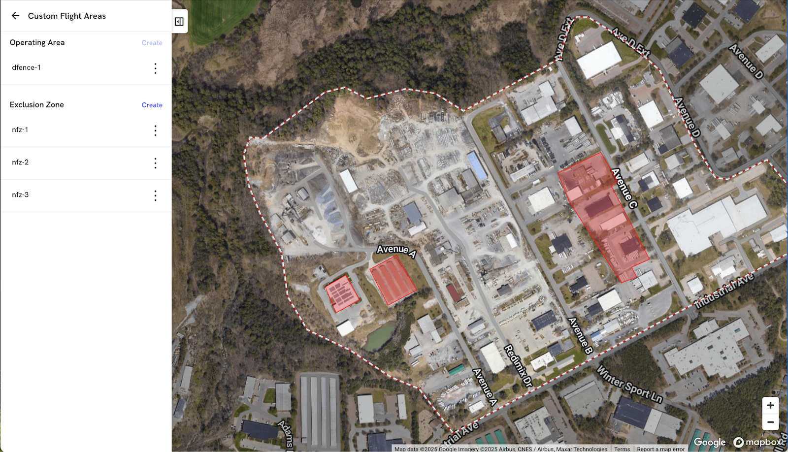
Feature Benefits
→ Draw operating areas and exclusion zones in the web app with no backend uploads or support requests.
→ See conflicts during planning and block non-compliant missions.
→ Standardize rules across RC and dock sites to simplify audits and reduce risk.
→ Available for both RC and dock drones.
Manual Flight for Dock
When the unexpected happens, take the stick instantly and get the mission back on track.
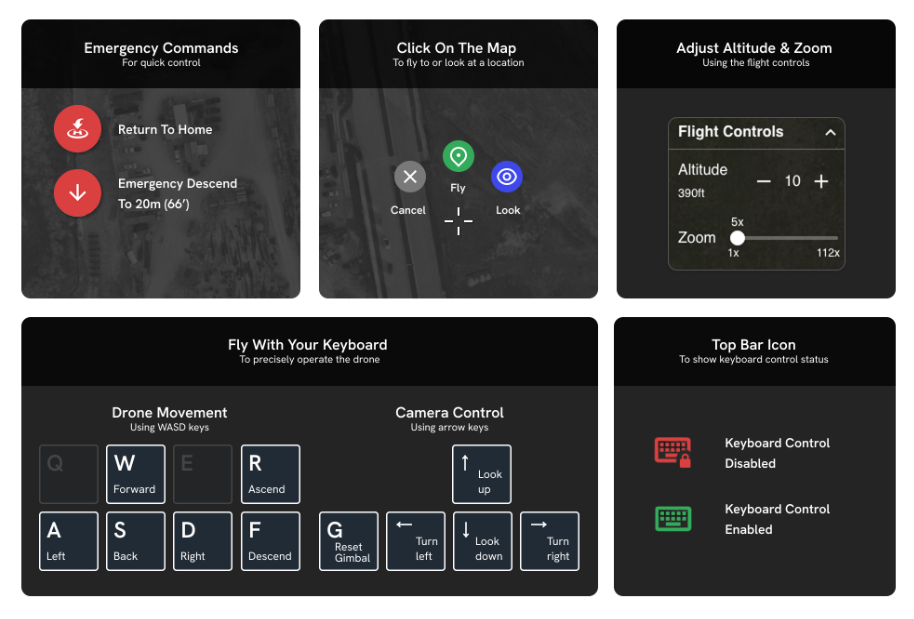
Feature Benefits
→ Launch your docked drone and inspect any part of your site without a flight plan.
→ Satisfy regulatory requirements and give operators instant manual control to avoid hazards or safely terminate a mission.
→ Immediate manual override for on-demand views, keyboard controls for precise positioning.
→ Pause – investigate – resume the mission; capture photos/video mid-flight to document issues.
DroneDeploy Ground
Insta360 X5 Support
The Insta360 X5 brings larger dual sensor chips for the best low light visibility reality capture. With high dynamic range, your 360 walks will be balanced, clear, and capture every detail whether you are working in low light, bright light or mixed conditions.
Feature Benefits:
→ 144% Larger dual sensors (1”/1.28”)
→ Higher dynamic range for better results across low and bright light conditions
→ Improved stitching generates better results in narrow hallways
→ Swappable batteries keep users going even when needing to replace batteries
Import and auto sync BIM from Autodesk Construction Cloud
Automates BIM version management in Autodesk Construction Cloud and enables visual comparison between design models and panoramic site captures for construction progress validation.

Upload a new BIM Version without need for realignment
The new “Replace BIM” button in the BIM section of Project Settings applies the same alignment to a new BIM as the previous model version, eliminating the need to realign the model.
BIM Compare against a 360 Pano
Side by side comparison of a model against a 360 pano image enables real-time quality control and progress validation.
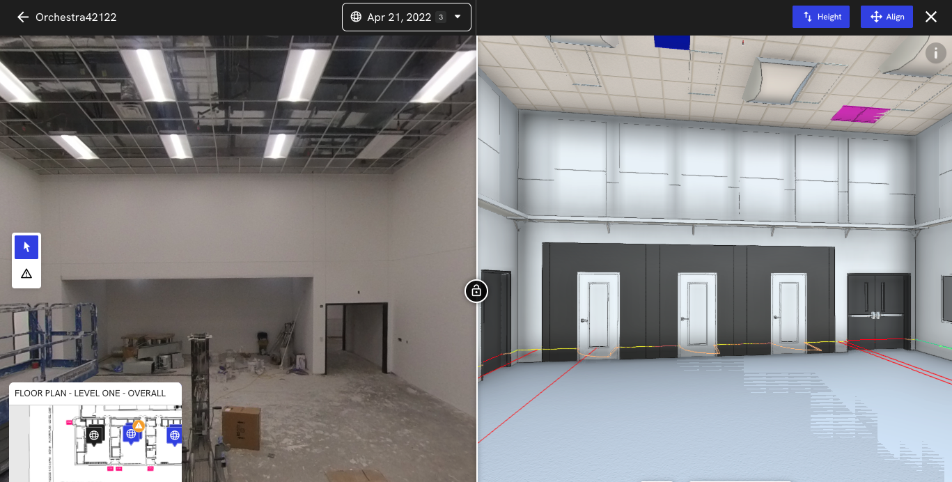
Feature Beneifts
→ Eliminate repeated BIM alignment work by 75%
→ Simple validation of progress with BIM compare vs pano images
→ Streamlined ACC (Autodesk Construction Cloud) integration eliminates file transfer steps and saves time
.png)
FAQ


Ready to manage your data from the very start?
Book a quick call to see how DroneDeploy streamlines capture from construction through building ROI.